
Pushing Atmospheric Remote Sensing Forward: Extending Complete Data Fusion to Tomographic Retrievals
Satellite remote sensing has revolutionized our understanding of Earth’s atmosphere, but merging data from different instruments—each with unique strengths—remains one of the biggest scientific challenges. A new study published in Atmospheric Measurement Techniques (2025) presents a major step forward: the extension of the Complete Data Fusion (CDF) algorithm to tomographic (2D) atmospheric retrievals.
This innovation could significantly enhance how scientists integrate limb‑viewing and nadir‑viewing satellite data, ultimately improving our ability to observe and understand complex atmospheric processes.
What’s New in This Study?
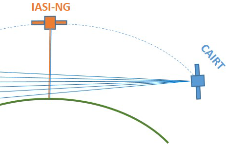
The researchers successfully extended CDF to handle two‑dimensional (2D) tomographic retrieval products. This enables the fusion of datasets that include both vertical and horizontal information—crucial for capturing the geometry of atmospheric structures.To demonstrate this, they tested the method on simulated ozone datasets from two future missions:
IASI‑NG (Infrared Atmospheric Sounding Interferometer – New Generation), a nadir‑viewing instrument
CAIRT (Changing‑Atmosphere Infrared Tomography), an ESA Earth Explorer 11 candidate mission providing limb tomographic observations.
These two sensors observe the atmosphere in very different ways. By combining...